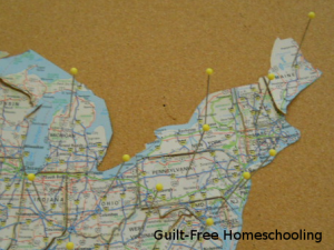
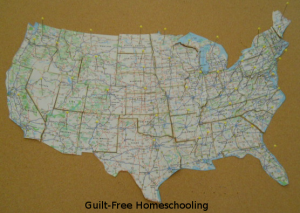
Take one large, atlas map of the USA (preferably an older one, not the one needed for an upcoming vacation or business trip). Cut it apart on state borders; mine was a 2-page map, so I taped the pages together before cutting the states apart. Optional: Leave the smaller states of Rhode Island, Connecticut, Massachusetts, Vermont, & New Hampshire together as one unit, making them slightly harder to lose. Using a large bulletin board and some long “quilting” pins (mine are approx. 1 5/8″ long), reassemble the map by pinning the state puzzle pieces in place on the board, forming the contiguous 48 states.

This puzzle can take students further than traditional USA jigsaw puzzles, since the pieces are not different colors and the highway markings can be used as clues for lining up the pieces. State borders become less noticeable, and major cities, highways, lakes, rivers, and other geological features are included on an atlas map, taking this from a simple puzzle activity to a fascinating exploration. The learning continues after the puzzle is assembled, by following the interstate highways from state to state, coast to coast, or border to border. Students can trace the route of a past family vacation or plan another, perhaps even evaluating various paths of travel across the country. Select two states at random and plot the most direct route from one to the other or the most scenic route or the best route to use during summer or winter driving for avoiding super-hot weather or snowy/icy roads. Older students who are nearing driving age may find this activity particularly interesting.

The map puzzle in these photos does not include Alaska or Hawaii, since they are usually not represented on maps in the same scale as the other states. The state of Hawaii consists of more than 100 islands, not just the eight larger islands we usually see on maps. The total land area of the Hawaiian islands is less than the area of the state of New Jersey, but greater than the area of the state of Connecticut. Alaska has more than twice the land mass of Texas, but Alaska’s boundaries and archipelago islands stretch its dimensions to massive proportions (see link below). Other state-to-state comparisons can easily be made with these puzzle pieces. A globe or world map is also helpful in comparing size and location of the various states, using latitude and longitude lines as guides.
Another way to supplement your explorations is with Google Maps. Use the satellite views to zoom in on tiny islands or coastal details, or visit the Grand Canyon, Mount Rushmore, Niagara Falls, or New York City’s Central Park (or anywhere else!) with Google Street View to take a virtual field trip! Many locations include a selection of up-close-and-personal photos from previous visitors to enhance your “travels.”
Here is a map showing the full size of Alaska as compared to the continental USA — http://www.tongass-seis.net/media/images/AK-USA.jpg
Other topics could be explored with a little extra research, then compared to today’s highways on this puzzle map:
The Appalachian Trail
The Lewis & Clark Expedition
The Oregon Trail
The Santa Fe Trail
…and many others!
Similar puzzles can be made from other maps for more fun geography — state road maps cut on county lines; a Canadian map cut on province boundaries; a map of Mexico or Australia cut on state borders; a map of South America, Europe, Africa, or Asia cut on borders between countries.


 Guilt-Free Homeschooling is the creation of Carolyn Morrison and her daughter, Jennifer Leonhard. After serious disappointments with public school, Carolyn spent the next 11 years homeschooling her two children, from elementary to high school graduation and college admission. Refusing to force new homeschooling families to re-invent the wheel, Carolyn and Jennifer now share their encouragement, support, tips, and tricks, filling their blog with "all the answers we were looking for as a new-to-homeschooling family" and making this website a valuable resource for parents, not just a daily journal. Guilt-Free Homeschooling -- Equipping Parents for Homeschooling Success!

[…] Customized Homeschool ID Cards Map Puzzle – Make your own! Embracing a Family Homeschool Culture Printable Notebooking Covers […]